|
 J. A. Gilreath's Dipmeter Rules
Over
the years, J. A. Gilreath of Schlumberger has been recognized
as the foremost dipmeter interpreter. He has published numerous
case histories, and this set in Schlumberger Technical
Review (July 1987) entitled "Dipmeter Interpretation Rules",
as well as an expanded version as "Strategies for Dipmeter
Interpretation".
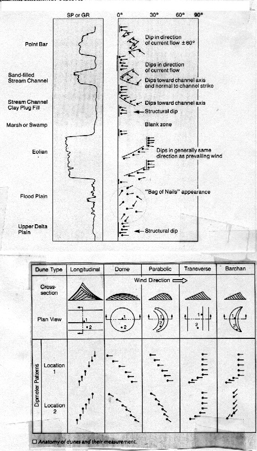
Nonmarine / Continental Deposits
The four structural (green) dip patterns indicate sediments deposited
essentially flat in an upper delta plain.
The
yellow "bag-of-nails" pattern near the bottom results
from disturbed bedding from high energy surges in the food plain.
There are few, if any, structural dips in such environments.
The
green over blue patterns are characteristic of eolian dunes, especially
transverse and barchan. The wind blew toward the downdip direction
(west to east). Dome and parabolic dunes produce mainly red patterns,
also with the wind blowing downdip. Longitudinal dunes produce
red or blue patterns with dip direction normal to prevailing wind
direction.
Blank
zones result from destruction of bedding planes from bioturbation
and rooting, indicating marsh or swamp deposits.
Red
dip patterns within shale zones, indicated on the spontaneous
potential or gamma ray curve, suggest clay filled stream channels.
The downdip direction is toward the stream axis.
The
blue over red pattern, with the blue dipping normal to the red,
and the SP/GR curve indicating sand, suggests a stream channel.
The red dips are normal to channel strike (northwest-southeast).
Flow direction is downdip of the blue pattern (to the southeast).
Several
blue patterns at the top of the log are typical of point bar sands,
when core and other geological studies indicate a fluvial environment.
These dips are in the direction of current flow +/- 60 degrees.
If the patterns extend more than 3 feet, they probably result
form accretion deposits, which dip toward the meander direction,
rather than from trough cross-bedding, in which they would dip
down current.

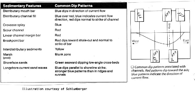
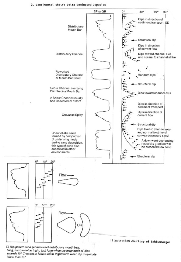
Continental Shelf: Delta Dominated Deposits
At the base, the sudden decrease in the SP/GR log is of limited
use here, but coupled with an increase in the resistivity log
(not shown), it would indicate compaction of a mud, probably by
an overlying sand. The long, sweeping red pattern suggests a channel
sand. The red dips are normal to the axis of the sand. Such sands
can be more than 2,000 feet thick.
Moving
up, the blue patterns can indicate either a crevasse splay or
a distributary point bar. The sawtooth SP/GR curve, indicating
pulses of deposition, is not much help, since it is associated
with many features. Resorting to information from other wells
can be helpful and often necessary to distinguish crevasse splays
from distributary point bars. Sands limited in areal extent suggest
a crevasse splay; extensive sands suggest a distributary a mouth
bar. In this example, current flow is downdip (southeast). The
underlying structural dip (green) probably indicates that the
splay or bar formed over a flat lying delta outwash plain.
Red
over blue patterns dipping in parallel are characteristic of a
distributary mouth bar sand topped by a scour channel. The blue
patterns, which result from foreset bed deposition, dip in the
direction of current flow (to the east-southeast) and the red
patterns, which result from drape over the base of the channel,
dip toward the scour channel axis (east-southeast).
The
overlying yellow pattern could have a few causes, but is most
likely a reworked distributary channel or mouth bar sands, since
it is sandwiched between channel deposits. These sands tend to
be clean, with good permeability and porosity.
The
red pattern (from drape), overlain by a blue pattern (from foreset
beds) dipping normal to it, suggests a distributary channel. The
red pattern dips toward the channel axis, and the blue pattern
dips downstream (south).
The
topmost feature was identified as a distributary mouth bar based
on studies in other wells. Based on the dipmeter plot alone, the
bar is indistinguishable from a crevasse splay. The multiwell
study, however, permitted mapping a channel. It was logical to
conclude that the blue patterns at what seemed to be the end of
the channel must indicate a distributary mouth bar.
In
general, blue patterns dipping away from the channel axis indicate
crevasse splays; blue patterns dipping parallel to channel strike
are due to a distributary mouth bar. Variation in dip magnitude
gives some indication about the shape of the distributary mouth
bar. When dip varies 10 degrees or more, the bar tends to be elongate
downdip. When dip varies less than 10 degrees, the bar tends to
be crescent or fan shaped.
Continental Shelf: Tide, Wave, and Current Dominated Deposits
Stratigraphic features of this environment are often the result
of reworking of previously deposited deltaic sediments.
The
two green patterns at bottom are interpreted as parallel cross-beds
dipping seaward about 20 degrees. Existing knowledge of the area's
lithology, based on cores or density and neutron logs, established
this as a carbonate zone, The parallel cross-bedding could be
from an eolian feature, but it probably indicates beachrock, a
carbonate that forms at the saltwater-freshwater interface along
the shoreline.
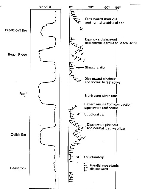
The
red pattern, produced by drape, overlying the blue pattern, produced
by cross-bedding, indicates a bar. The pinchout is downdip (northeast)
and the strike of the bar is normal to dip (northwest-southeast).
Dips within the bar are irrelevant. The key sign of a bar or reef
is a red pattern, which indicates a convex upward feature, above
a permeable zone, A blue pattern, indicating a convex downward
feature, above a permeable zone would suggest a channel.
The
next zone shows more characteristics of a reef: a blank zone caused
by massive, non-bedded reef material over a blue pattern, caused
by mud compaction, and under a red pattern, caused by drape over
the reef flank. The red patterns dip toward the pinchout (east-northeast)
and normal to the strike of the reef (north-northwest by south-southeast).
The blue pattern, which results from compaction, dips toward the
thickest part of the reef.
The
next set of red patterns overlying numerous dips at odd angles
suggests a buried beach ridge, Beach ridges typically have dips
in many directions, as opposed to bar deposits, which tend to
have uniform dips from reworking by waves. The red patterns indicate
the top of the ridge and the numerous dips indicate the ridge's
interior. The red patterns dip toward the shale-out (northeast)
and normal to the strike of the beach (northwest-southeast).
Finally,
the uppermost red pattern overlying two dips normal to the general
red trend suggests a sand bar that formed at the wave breakpoint.
The homogeneity of the dips is strong evidence for reworking,
a characteristic of breakpoint bars. The red pattern dips toward
shale-out (northeast) and normal to the strike of the bar (northwest-southeast).
Breakpoint bars can be distinguished from longshore current sand
waves in that the former are usually overlain by a red pattern,
and the latter have blue patterns within the sand. Dips in both
can be seaward or landward.

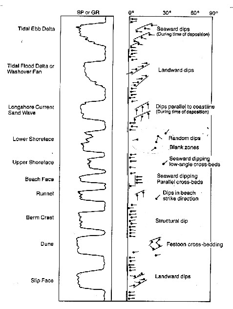
Continental Shelf: Tide, Wave, and Current Dominated Deposits
Based on knowledge that the well intersects a beach, the bottommost
blue pattern, sandwiched between green patterns, indicates a slip
face sand on the landward side of the beach. The blue dips point
landward (west) and are normal to the beach strike (north-south).
Again,
based on knowledge of a beach environment, the collection of varying
blue patterns with dips landward indicates festoon cross-bedding.
This type of a bedding is common in primary dunes, the first row
behind the beachface, and is caused by variations in wind direction.
The overlying green pattern probably indicates a berm.
The
few overlying random dips overlain by a blue pattern suggest a
runnel (a small stream or channel): the blue pattern derives from
mega-ripples and the random dips are from small scale ripples.
Small scale ripples can also produce blank zones. The dip of the
mega-ripples parallels the strike of the beach (north-south).
Above
the runnel, green patterns of varying dip magnitude suggest parallel
cross-bedding in beachface sands. Since the sea was downdip of
the cross-bedding, at the time of deposition it lay to the east.
The flatter lying sands above suggest the lower energy environment
of the upper shoreface sands. The random dips above suggest the
high energy and bioturbation of the lower shoreface. This area
can also be indicated by a blank zone.
Blue
patterns overlying green suggest longshore current sand waves
overlying a fossil shoreline, given knowledge of a silicate shore.
The blue patterns dip in the direction of longshore transport
(from north to south) and parallel the shoreline strike (north-south).
Landward
dipping blue patterns indicate landward sediment transport, probably
produced by a tidal flood delta or a washover fan. The overlying
seaward dipping blue pattern suggests a tidal ebb delta.
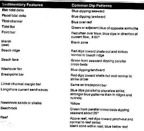
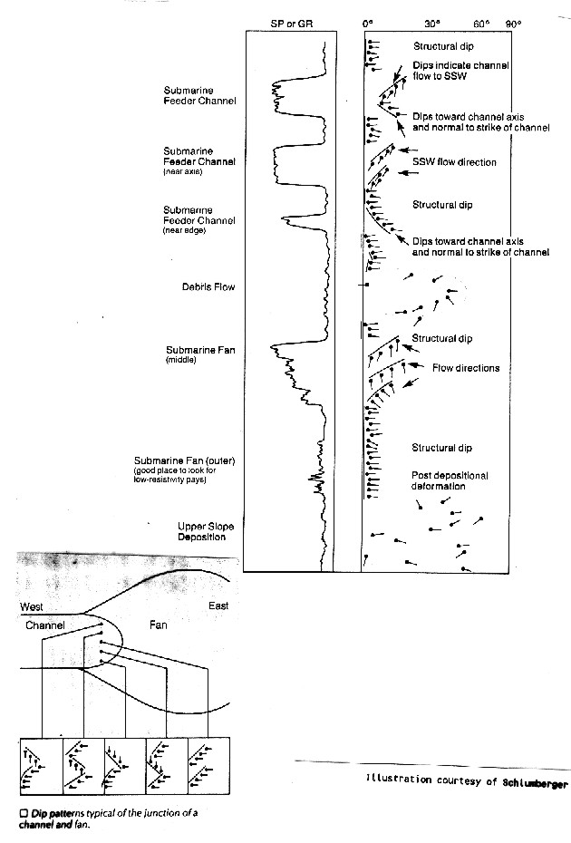
Continental Slope and Abyssal Deposits
Sediments in the deep waters of the continental slope and beyond
often undergo post-depositional movement that produces random
dips. Paleostructural dip, consequently, is difficult to determine
in these environments. Dips that appear to be structural can indicate
the most common flat lying features; submarine fans and feeder
channels.
Reading the log from the bottom, the yellow pattern suggests either
a debris flow or upper slope deposits that were deformed after
deposition. Distinguishing between the two requires data from
a core or a formation microscanner log. Above them, the structural
dip and evidence in the SP/GR log of alternating sand/shale layers
suggest the low lying outer edge of a submarine fan.
Farther
up, the appearance of blue patterns from cross-bedding suggests
either the axis of a feeder channel or the mid-fan. MId-fan deposits,
however, are much more common. Sediment transport is in the downdip
direction of the blue pattern (north to south).
Independent
information from cores indicated the second yellow pattern results
from highly deformed sediments, probably from a debris flow. The
following patterns suggest the various parts of a submarine feeder
channel. Red indicates the edge of the channel, with the dip toward
the channel axis (axis to the east) and normal to channel strike
(north-south). The two blue patterns above suggest the channel
axis, with transport direction downdip (toward south-southwest).
Finally, the blue over red patterns, with dips 90 degrees apart,
indicate an area of the channel between the axis and the edge.
The red pattern, again, dips toward the channel axis and normal
to channel strike, and the downdip direction of the blue pattern
indicates the transport direction.
The
decline in SP/GR values with depth in the mid-fan suggests the
sand is getting coarser with depth. This occurs because the first
deposits of a fan are the finest, then, as the fan builds out,
coarser sediments are carried farther. Finally, the uppermost
layer, which was nearest shore, will be the coarsest. The numerous
SP/GR excursions in the outer fan indicate alternating sand-shale
layers.
|