|
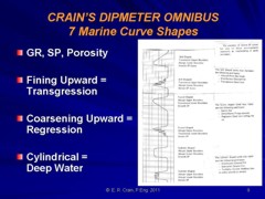
 Marine Transgressive Overlap - Fining Upward Sequence
A sedimentary structure is generally initiated by the accumulation
of sediment on an old erosion surface. Deposition does not occur
everywhere at once. Sediment will be deposited gradually at a
location close to the source of sediments and will be spread outward
from the source. This process is called overlap since the new
sediments gradually overlap onto the older sediments.
Two
kinds of overlap are recognized. Transgressive overlap occurs
when the sea is advancing, or transgressing, upon a low,
relatively flat land mass. In this case the land mass is
subsiding relative to sea level. At the shore line, sand and
gravel accumulate. Away from the land, beyond the beach sands,
mud is laid down, and beyond that there may be organic oozes
deposited on the sea floor.
Transgressive overlap - fining upward sequence (top)
Regressive overlap - coarsening upward sequence (bottom)
The
sand, mud, and lime phases extend along the coast in three roughly
parallel belts. As the sea encroaches on the land, the three types
of deposits remain in the same relative position to each other,
but they shift landward. The beach sand and pebbles are laid down
on the old erosional surface. The mud from this phase overlies
the sand deposited earlier, and the ooze overlies the older mud
layer. Thus mud overlaps the sand and ooze overlaps the mud. This
is marine transgressive overlap, and grain size becomes finer
in the upward direction.
Thus,
a vertical section through the formation shows finer grained rocks
lying over coarser rocks, or deep water sediments over shallow
water sediments. These sands are described as "fining upward".
The gamma ray and SP curve shapes are shown below , and are called bell shaped curves, due to the visual effect
generated by a pair of regular and mirror image curves. Typical transgressive sedimentary structures are alluvial point bars in
meandering rivers and tidal channels. Delta distributary channel
fill can also show transgressive curve shapes, but more show regressive
or high energy shapes.
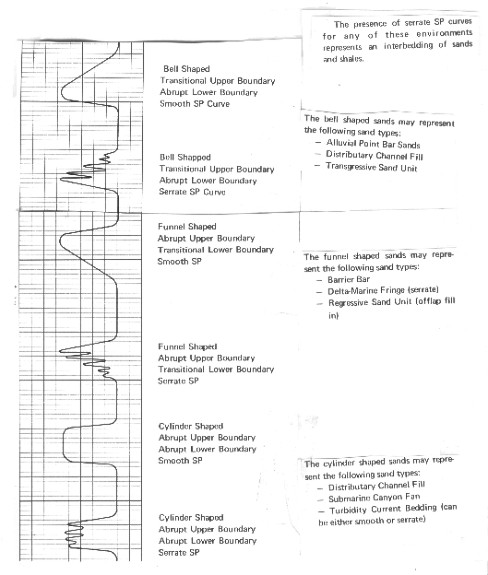
Fining upward, coarsening upward, and cylindrical
curve shapes
A
serrated or saw tooth curve shape may be superimposed on a bell
shaped curve; this is caused by interbeds of shale between the
sand layers. Such interbeds represent short periods of deeper
water deposition, possibly caused by floods or erratic transport
of sediments.
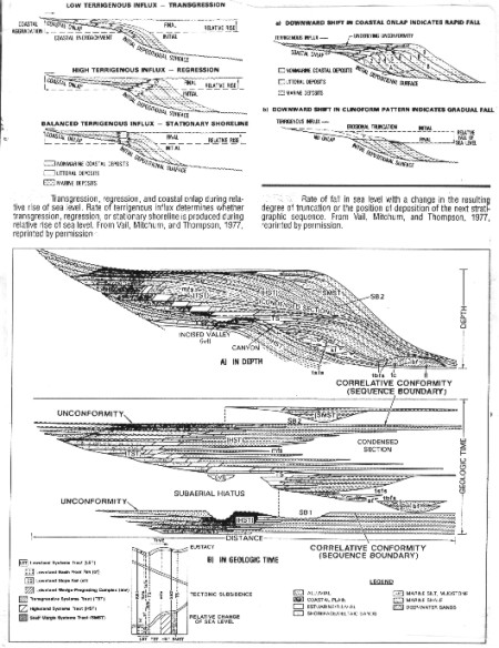
Marine
Regressive Overlap - Coarsening Upward Sequence
Regressive overlap is produced when the sea recedes from the land,
as when the land mass is uplifted or the sea bed subsides. By
this process, the beach zone migrates out over earlier offshore
muds. See bottom half of previous illustration. At the seaward end, mud beds
overlap the older ooze. A vertical section shows coarser material
overlying finer material, or shallow water sediments overlying
deep water sediments. These sands are described as "coarsening
upward" and have a gamma ray or SP curve shape as in
the center of the illustration shown above. These are called funnel shaped curves
and would be indicative of barrier bars, or the edge of delta
fronts. These curve shapes may also be serrated or saw tooth shaped.
Sea
level dropping relative to the land is not necessary for marine
regressive overlap. The same regressive sequence is produced if
the sea level is stationary and there is sufficient supply of
sediments, or even if the sea level is rising, provided the rate
of supply exceeds the rate of rise of the ocean.
Different
types of overlap often combine in the same stratigraphic section.
Thus the sea may advance on the land and then recede, so that
regressive overlap is found above transgression. This alternation
may be repeated many times.
High
Energy Marine Deposition - Cylindrical Sequence
Distributary channels in delta sequences represent high energy
deposition. At flood stage, these deposits will fill old channels
while new ones are formed. The sand bodies will be quite uniform,
with large grain size and little visible bedding. These form cylindrical
curve shapes, similar to those in the bottom illustrations. If flooding is erratic, the curve shape may be serrated.
Similar
curve shapes can be formed in deeper water as sand slides, or
fans, formed at the end of submerged canyons. Turbidite deposits,
formed in deep water by slumping of unconsolidated slopes or by
rapid movement of heavy, silt laden water, form serrated cylindrical
curve shapes, often covering hundreds or thousands of feet of
vertical section.
Curve Shape Patterns in
Continental Sequences
Bell shaped curves are found in alluvial point bar sands, in meandering
streams, and in drape inside a channel fill. Funnel shaped curves
occur in foreset and crossbeds in channels. Cylindrical patterns
are restricted to sand dunes and scree slopes, the latter being
often serrated.
There
are obvious ambiguities between marine and continental curve shapes,
so curve shape alone will not suffice to uniquely determine environment.
With all four sources of environmental data, namely curve shape,
dip angle and spread, bedding type, and shale volume, it is usually
possible to assess the environment and hence the sedimentary structure
quite precisely. If one source is missing, especially the dip
data, life becomes more difficult, but regional knowledge will
usually fill in the gaps.
|